I went hiking up Williams Canyon with someone I had never hiked with before.
She had grown up in this area and had hiked Williams Canyon many times as a youth and into adulthood.
Earlier this Spring, she had gone up just a short ways before, but it had gotten dark, and she was alone, so had turned back before going to far past the entrance sign.

I mentioned to her I really wanted to take a hike up here before the flood mitigation work began, so we picked a perfectly sunny day and took a hike up Williams Canyon. Neither of us had any desire to hike this canyon with even the slightest chance of rain.
The road approaching the entrance to the trail that goes up Williams Canyon didn’t look too bad. But then it had been cleaned up so that residents that lived up the road to the right could get to their homes.

But as one approached the Exit Only sign where a road used to be, the rubble and rocky path was very different from what it had looked like just a year ago.
The torn up drainage pipe was the first clue to the power of the flood waters that had come down this narrow canyon less than a year ago.
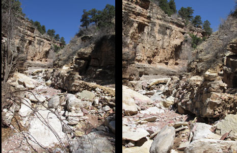
As we rounded the first bend on the trail, we were greeted with a very rocky and different path than what we had hiked on many times. The creek was totally rerouted to run down the middle of where the road used to be.
We could see where many people had hiked up here and created a new trail that we followed through this very rough area.
Actually, only a few places looked anything like the road had looked before. And yet, there were places that hadn’t seen as much damage or been so completely transformed as this area had been.
We kept hiking and at every turn found ourselves saying “Wow!” over and over again. We even commented that certainly we had more words in our vocabulary to describe what we were seeing, then we would turn a corner and let out a gasp and say “Wow!” again.
The devastation was everywhere, but it was also very beautiful in a new and different way from what we were used to seeing on this hiking trail.

Here are views looking up on section of trail and then back down. This section actually wasn’t as hard to transverse as some other sections.
We hiked carefully and slowly the whole time we were out here, and I was very glad I had my hiking pole with me in many sections. We actually sat down a few times when coming back down a few sections that were a bit more difficult than we felt comfortable staying on our feet.
There is a section that is called “The Narrows” and it had a sign that greeted people who used to drive down from the Cave of the Winds before the 1999 flooding and destruction of some sections of this road. The sign read “Yes, you can, thousands before you have.” This sign always brought a smile to my face. But on this hike, the sign was gone, and this was one of the first sections that was more challenging for getting past than I usually like to hike.

Very slowly we made our way past “The Narrows” that were much narrower than in the past. Getting past this area involved walking on the rusty culverts and crossing the creek a couple of times to stay on the most solid areas of the trail.
When we got to the place where “The Narrows” turned sharply, there was more destruction of the wall that had guided the river’s path for years. But when we turned the corner, this was where some of the road looked almost untouched.

Except for the huge sections of the wall that had been moved from their place along the creek bed into the roadway.

The power of the flood waters that caused these sections of the wall to be dislodged and moved such a distance was another view that brought about a “Wow!” from us both.